


(www.MaritimeCyprus.com) All anchoring operations form part of the passage plan, and should be sufficiently appraised, planned, executed, and monitored. This includes establishing an appropriate location in which to anchor. Crew should verify that the chosen designated anchorage is of suitable depth, and that the seabed composition will allow for safe anchoring of the vessel.
Anchoring in designated anchorages
A designated anchorage is of suitable depth and in a location that allows the vessels to swing safely. These designated anchoring areas can be identified by consulting the appropriate navigation chart. Alternative anchorages should be identified as a backup in case the initial location is unavailable.
Calculating the length of cable and swing circle
Once an anchoring location has been selected, it’s necessary to calculate the length of cable needed to hold position. There are two commonly used formulas for calculating the length of cable to be paid out:
- Amount of cable required (in shackles) = 1 ½ √water depth in metres (Admiralty Manual of Seamanship)
- Minimum amount of cable required (in metres) = 4 x depth of water in metres (D J House – Seamanship Techniques)
Having the swing circle laid out on the navigation chart is important for monitoring the vessel’s position. The swing circle can be plotted on the navigation chart. It is drawn from the “let go anchor” position and not from the “brought up to” position and is calculated using the length of the vessel and the number of shackles let go.
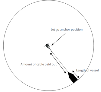
For example: a vessel 80 metres in length with 5 shackles paid out would have a swing circle radius of approximately (5 x 27.5m) + 80m = 217.5m (1.1 cables).
Consideration should also be given to the holding ground of the seabed, anchor holding power and prevailing weather conditions when determining the amount of cable to pay out.
Maintaining an anchor watch
An effective anchor watch will include frequently monitoring the vessel’s position, utilising different position fixing methods on an appropriate scale navigation chart, as well as using the anchor alarm settings on radar or ECDIS, if available. A regular check of the anchor cable direction and lead should also be conducted, to help detect if the anchor is dragging at an early stage. The position and movements of other vessels in the vicinity should also be monitored, allowing for early evasive action to be taken, if required.
When anchored in areas that pose a security threat, additional deck rounds and security measures may need to be implemented. You can find more information about piracy here.
Anchoring in adverse weather
The cause of dragging anchor is usually attributed to passing squalls or persistent high winds, especially those blowing over the tide (or current), or by the strong tide or current itself. The problem can be made worse in crowded anchorages, which may result in masters not being able to pay out additional cable. The bridge team should ensure that weather forecasts are regularly monitored, and consideration is given to seasonal weather patterns. Understanding the tides is also important, as dragging anchor often occurs after swinging on a changing tide. Control measures should be implemented in the event of worsening weather, these may include but are not limited to:
- Calling the Master
- Utilising navigation aids such as radar to monitor for approaching squalls
- Starting the main engines in good time or leaving them running where deemed appropriate
- Increasing the frequency with which the lead and weight on the anchor cable is checked
- Making use of the second anchor (if available)
- Ballasting the vessel to reduce the windage
- Heaving the anchor and putting to sea
Anchoring outside of a designated anchorage
From time to time, it may be necessary for a vessel to anchor in a non-designated location. This may be due to vessel operations, such as passenger day excursions, or in the event of an emergency. The master should ensure that there are no local restrictions prior to dropping the anchor.
When assessing the seabed for suitability, it is strongly recommended to check for potentially environmentally sensitive areas such as reefs, as there is a risk of damaging the subsea environment, which may lead to significant fines. In addition, subsea equipment and hazards such as cables and pipelines, should be highlighted on navigation charts for ease of reference.
It is likely that the only available information about the seabed will be located on navigation charts, or in local pilot books and so it is vital that these are consulted as part of the assessment. Particular attention should be paid to notes on navigation charts that may advise of uncommon hazards or restrictions present in the area. Do not deploy the anchor if there is any doubt as to whether it is permitted or safe to do so.
Where countries have neighbouring waters, it is important to ensure the selected anchoring location is in the intended country’s waters, with consideration made for any movement whilst at anchor.
Source: Shipowners' Club
Read also: Maritime Risk Focus: Loss of Anchor (Video and Guidance)